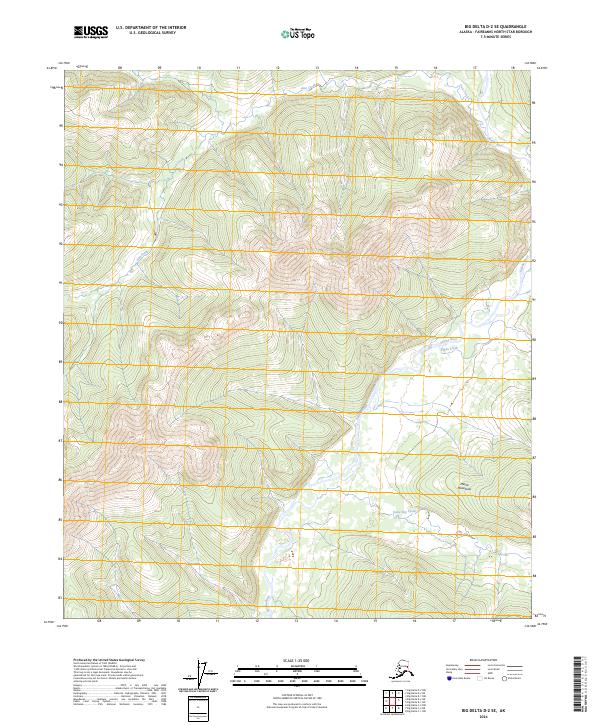
2024 Map of Big Delta D-2 SE
USGS Topo · Published 2024About this map
The Mertie Mountains dominate the southern portion of this interior Alaskan landscape, providing a high-relief backdrop to the complex drainage systems of the Fairbanks North Star Borough. The Salcha River snakes through the central and eastern sections of the quadrangle, serving as the primary hydrologic artery for numerous smaller tributaries. This 2024 survey documents a territory defined by its watershed patterns, where the north-flowing Dan Creek and the southern Stone Boy Creek carve deep valleys through the upland terrain. The lack of mapped roads or settlements emphasizes the remote nature of this wilderness area, which is organized primarily by the Public Land Survey System grids, including t1n r16e and t2s r15e. Researchers of Alaskan geography will find a detailed representation of the high-altitude topography and the relationship between the river basins and the surrounding peaks.
Find a feature on this map
11 named features on this map. Tap any name to fly to it.
Don’t see what you’re looking for? This feature index may not catch every label — zoom into the map to look around manually.
Map Details
Editions of this 2024 Big Delta D-2 SE Map
This is the sole edition of this map. No revisions or reprints were ever made.
Other maps of this area

1950 · Big Delta
USGS Topo · 1:250,000

1951 · Big Delta
USGS Topo · 1:250,000

1958 · Big Delta D-2
USGS Topo · 1:63,360

1958 · Big Delta D-1
USGS Topo · 1:63,360

1958 · Big Delta C-2
USGS Topo · 1:63,360

1958 · Big Delta C-1
USGS Topo · 1:63,360

1958 · Big Delta
USGS Topo · 1:250,000
2018 · Big Delta D-2 NE
USGS Topo · 1:25,000
2018 · Big Delta D-1 NW
USGS Topo · 1:25,000
2018 · Big Delta D-2 SW
USGS Topo · 1:25,000