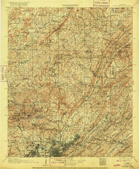
1907 Map of Birmingham
USGS Topo · Published 1916About this map
Industrial growth and iron-age expansion define the landscape in this early twentieth-century survey, centered on the burgeoning city of Birmingham. The map documents a dense network of early industrial settlements including Pratt City, Ensley, and Wylam, all supported by an intricate rail system featuring the Louisville and Nashville RR and Southern Ry. These rail lines weave through the ridges of Red Mountain and Sand Mountain, connecting the urban core to outlying operations like the Watts Mines and Coaldale.
Find a feature on this map
108 named features on this map. Tap any name to fly to it.
Don’t see what you’re looking for? This feature index may not catch every label — zoom into the map to look around manually.
Map Details
Editions of this 1907 Birmingham Map
5 editions found

Other maps of this area

1885 · Gadsden
USGS Topo · 1:125,000

1888 · Cullman
USGS Topo · 1:125,000

1888 · Gadsden
USGS Topo · 1:125,000

1889 · Springville
USGS Topo · 1:125,000

1889 · Birmingham
USGS Topo · 1:125,000

1890 · Bessemer
USGS Topo · 1:125,000

1890 · Talladega
USGS Topo · 1:125,000

1892 · Cullman
USGS Topo · 1:125,000

1892 · Birmingham
USGS Topo · 1:125,000

1892 · Springville
USGS Topo · 1:125,000