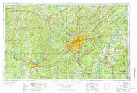
1953 Map of Birmingham
USGS Topo · Published 1976About this map
Birmingham sits at the heart of this regional study, showing the industrial center's mid-century expansion toward Bessemer, Fairfield, and Homewood. The map illustrates the complex rail network that built the Magic City, featuring the Southern Railway and Louisville and Nashville Railroad alongside the developing interstate system. To the west, the winding Black Warrior River and the Mulberry Fork define the terrain of the coal-rich Walker County, while the northeast is dominated by the Appalachian Mountains and the strategic Fort McClellan Military Reservation near Gadsden.
Find a feature on this map
105 named features on this map. Tap any name to fly to it.
Don’t see what you’re looking for? This feature index may not catch every label — zoom into the map to look around manually.
Map Details
Editions of this 1953 Birmingham Map
4 editions found

Other maps of this area

1885 · Gadsden
USGS Topo · 1:125,000

1888 · Cullman
USGS Topo · 1:125,000

1888 · Gadsden
USGS Topo · 1:125,000

1889 · Springville
USGS Topo · 1:125,000

1889 · Birmingham
USGS Topo · 1:125,000

1890 · Bessemer
USGS Topo · 1:125,000

1890 · Talladega
USGS Topo · 1:125,000

1891 · Clanton
USGS Topo · 1:125,000

1891 · Ashland
USGS Topo · 1:125,000

1892 · Cullman
USGS Topo · 1:125,000