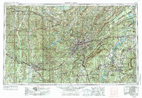
1953 Map of Birmingham
USGS Topo · Published 1976About this map
Birmingham serves as the industrial and topographic center of this regional survey, which illustrates the ridge-and-valley landscape of the Appalachian Mountains at mid-century. The concentrated iron ore and coal extraction that fueled the city's growth is visible in the alignment of Red Ore Mines along Red Mountain, including the Pyne Mine and Ishkooda Mines. This geography created a distinct settlement pattern where industrial centers like Bessemer and Fairfield sit in the valleys, separated by steep ridges from residential areas such as Mountain Brook.
Find a feature on this map
232 named features on this map. Tap any name to fly to it.
Don’t see what you’re looking for? This feature index may not catch every label — zoom into the map to look around manually.
Map Details
Editions of this 1953 Birmingham Map
4 editions found

Other maps of this area

1885 · Gadsden
USGS Topo · 1:125,000

1888 · Cullman
USGS Topo · 1:125,000

1888 · Gadsden
USGS Topo · 1:125,000

1889 · Springville
USGS Topo · 1:125,000

1889 · Birmingham
USGS Topo · 1:125,000

1890 · Bessemer
USGS Topo · 1:125,000

1890 · Talladega
USGS Topo · 1:125,000

1891 · Clanton
USGS Topo · 1:125,000

1891 · Ashland
USGS Topo · 1:125,000

1892 · Cullman
USGS Topo · 1:125,000