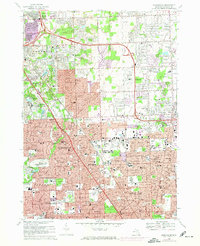
1968 Map of Birmingham
USGS Topo · Published 1974About this map
The Rouge River winds through this Oakland County landscape, marking a transition from the established neighborhoods of Birmingham and Royal Oak to the emerging suburban tracts of Troy and Bloomfield. This period of growth is highlighted by the purple tinting of expanding urban areas, particularly around the Grand Trunk Western railroad corridor. Significant institutional footprints are visible, from the massive Beaumont Hospital complex to the extensive grounds of White Chapel Cemetery and Roseland Park Cemetery. Educational and religious sites like the Shrine of the Little Flower Sch and Seaholm High Sch anchor the residential blocks. For local historians, the map preserves the alignment of arterial routes like Big Beaver Road and the early layout of Lathrup Village and Clawson before decades of further commercial development.
Find a feature on this map
144 named features on this map. Tap any name to fly to it.
Don’t see what you’re looking for? This feature index may not catch every label — zoom into the map to look around manually.
Map Details
Editions of this 1968 Birmingham Map
4 editions found



Other maps of this area

1905 · Wayne
USGS Topo · 1:62,500

1905 · Detroit
USGS Topo · 1:62,500

1907 · Pontiac
USGS Topo · 1:62,500

1908 · Rochester
USGS Topo · 1:62,500

1912 · Wayne
USGS Topo · 1:62,500

1918 · Detroit
USGS Topo · 1:62,500

1924 · Detroit
USGS Topo · 1:62,500

1934 · Detroit
USGS Topo · 1:62,500

1936 · Warren
USGS Topo · 1:31,680

1936 · Birmingham
USGS Topo · 1:31,680