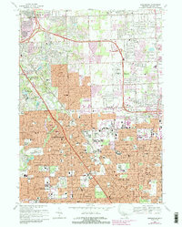
1968 Map of Birmingham
USGS Topo · Published 1989About this map
The northern suburbs of Detroit, including Birmingham, Troy, and Royal Oak, are shown here during a period of rapid post-war expansion. The map highlights the transition from traditional residential grids to extensive highway-oriented developments, particularly along the Interstate 75 corridor. Significant institutional landmarks dominate the landscape, from the sprawling Beaumont Hospital complex to the renowned Cranbrook Sch campus. The Grand Trunk Western railroad cuts diagonally through the terrain, serving as a reminder of the earlier industrial and commuter infrastructure that initially shaped these communities. Large-scale recreational and memorial spaces are prominent, including the Sylvan Glen Golf Course and the massive grounds of White Chapel Cemetery, reflecting the area's development into a major metropolitan residential hub. Urban growth is specifically tracked through purple-tinted revisions, illustrating the encroaching residential density near the Troy-Oakland Airport and the historic settlement of Big Beaver.
Find a feature on this map
139 named features on this map. Tap any name to fly to it.
Don’t see what you’re looking for? This feature index may not catch every label — zoom into the map to look around manually.
Map Details
Editions of this 1968 Birmingham Map
4 editions found

Other maps of this area

1905 · Wayne
USGS Topo · 1:62,500

1905 · Detroit
USGS Topo · 1:62,500

1907 · Pontiac
USGS Topo · 1:62,500

1908 · Rochester
USGS Topo · 1:62,500

1912 · Wayne
USGS Topo · 1:62,500

1918 · Detroit
USGS Topo · 1:62,500

1924 · Detroit
USGS Topo · 1:62,500

1934 · Detroit
USGS Topo · 1:62,500

1936 · Warren
USGS Topo · 1:31,680

1936 · Birmingham
USGS Topo · 1:31,680