
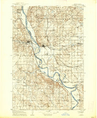
1907 Map of Bismarck
USGS Topo · Published 1907About this map
Bismarck stands as a developing state capital in the early twentieth century, anchored by the Capitol building and the nearby State Penitentiary. The city is a critical junction for the Northern Pacific railroad, which crosses the Missouri River into Mandan. This 1905 survey, published just before statehood’s second decade, reveals a landscape defined by military and transport history. To the south, the map details the grounds of Fort Lincoln and the site of Fort Rice, while the Fort Yates Stage Road provides a glimpse into the overland transit networks of the era. The rural hinterlands are dotted with community landmarks like Glencoe Church and Boyd School, while the river's dynamic channel is marked by Sibley Island and the meandering Little Heart River.
Find a feature on this map
65 named features on this map. Tap any name to fly to it.
Don’t see what you’re looking for? This feature index may not catch every label — zoom into the map to look around manually.
Map Details
Editions of this 1907 Bismarck Map
2 editions found
Other maps of this area

1950 · Wilton
USGS Topo · 1:62,500

1950 · Bismarck
USGS Topo · 1:24,000

1951 · Menoken SW
USGS Topo · 1:24,000

1951 · Bismarck
USGS Topo · 1:62,500

1951 · Mandan
USGS Topo · 1:24,000

1951 · Menoken
USGS Topo · 1:62,500

1951 · McKenzie
USGS Topo · 1:62,500

1954 · Bismarck
USGS Topo · 1:250,000

1954 · McClusky
USGS Topo · 1:250,000

1958 · Bismarck
USGS Topo · 1:250,000