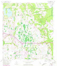
1953 Map of Bithlo
USGS Topo · Published 1981About this map
Bithlo and Christmas emerge as primary focal points in this eastern Florida landscape during the mid-20th century. The area is defined by its complex hydrology, where the Econlockhatchee River and numerous tributaries like Long Branch, Joshua Creek, and Roberts Branch weave through low-lying terrain. The transition of the local economy is visible through the alignment of the Cheney Highway alongside remnants of former infrastructure, notably the Old Railroad Grade in the south.
Find a feature on this map
22 named features on this map. Tap any name to fly to it.
Don’t see what you’re looking for? This feature index may not catch every label — zoom into the map to look around manually.
Map Details
Editions of this 1953 Bithlo Map
5 editions found
Other maps of this area

1950 · Aurantia
USGS Topo · 1:24,000

1953 · Narcoossee NE
USGS Topo · 1:24,000

1953 · Geneva
USGS Topo · 1:24,000

1953 · Titusville SW
USGS Topo · 1:24,000

1953 · Oviedo SW
USGS Topo · 1:24,000

1953 · Lake Poinsett NW
USGS Topo · 1:24,000

1953 · Narcoossee NW
USGS Topo · 1:24,000

1953 · Bithlo
USGS Topo · 1:24,000

1955 · Orlando
USGS Topo · 1:250,000

1956 · Oviedo
USGS Topo · 1:24,000