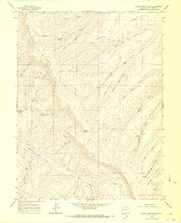
1964 Map of Black Cabin Gulch
USGS Topo · Published 1968About this map
Cathedral Bluffs dominate the topography of this Colorado plateau in the mid-1960s, a landscape defined by deep drainages and high-altitude ridges. The area reflects an era of early resource exploration and backcountry access, marked by numerous prospects and a solitary Landing Strip positioned on a high mesa between Right Fork Stake Springs Draw and Left Fork Stake Springs Draw.
Find a feature on this map
30 named features on this map. Tap any name to fly to it.
Don’t see what you’re looking for? This feature index may not catch every label — zoom into the map to look around manually.
Map Details
Editions of this 1964 Black Cabin Gulch Map
3 editions found

Other maps of this area

1929 · Highmore
USGS Topo · 1:62,500

1952 · Wolf Ridge
USGS Topo · 1:24,000

1952 · Yankee Gulch
USGS Topo · 1:24,000

1956 · Grand Junction
USGS Topo · 1:250,000

1959 · Grand Junction
USGS Topo · 1:250,000

1960 · Grand Junction
USGS Topo · 1:250,000

1962 · Grand Junction
USGS Topo · 1:250,000

1964 · Grand Junction
USGS Topo · 1:250,000

1964 · Brushy Point
USGS Topo · 1:24,000
1964 · Philadelphia Creek
USGS Topo · 1:24,000