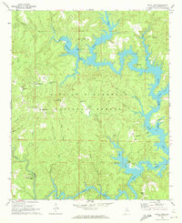
1969 Map of Black Pond
USGS Topo · Published 1972About this map
Lewis Smith Lake dominates the eastern half of this landscape, its deep fingers reaching into the William B Bankhead National Forest along the Sipsey Fork and Clear Creek. The late 1960s terrain shows a transition from the dense woodlands of the national forest to the developed shorelines around Arley Landing and the inland settlement of Black Pond. In the southern reaches, Falls City sits near the confluence of Coon Creek and Clear Creek, while the Black Pond Lookout Tower stands as a central landmark for forest management. Genealogists will find a wealth of family-named sites, including the Williams, Bennett, and Wilson cemeteries, alongside rural congregations like Union Grove Ch and the McDowell Memorial Chapel. The map even preserves evidence of older transit patterns, such as Slick Ford on Yellow Creek.
Find a feature on this map
42 named features on this map. Tap any name to fly to it.
Don’t see what you’re looking for? This feature index may not catch every label — zoom into the map to look around manually.
Map Details
Editions of this 1969 Black Pond Map
2 editions found
Other maps of this area

1893 · Jasper
USGS Topo · 1:125,000

1949 · Manchester
USGS Topo · 1:24,000

1949 · Nauvoo
USGS Topo · 1:24,000

1949 · Sunlight
USGS Topo · 1:24,000

1950 · Nauvoo
USGS Topo · 1:24,000

1950 · Manchester
USGS Topo · 1:24,000
1951 · Sunlight
USGS Topo · 1:24,000

1953 · Birmingham
USGS Topo · 1:250,000

1956 · Birmingham
USGS Topo · 1:250,000

1956 · Gadsden
USGS Topo · 1:250,000