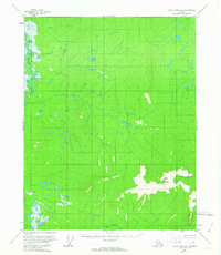
1956 Map of Black River A-4
USGS Topo · Published 1963About this map
The Little Black River winds through the northwestern corner of this 1956 survey, defining a landscape of low-lying wetlands and countless small, unnamed ponds. This interior Alaskan terrain transitions sharply in the south, where the elevation rises toward the prominent massif of Bear Mountain. This peak dominates the southeastern quadrant, serving as the headwaters for Bear Creek, which drains toward the southern map boundary. Based on aerial photography from 1955 and field annotated in 1956, the map shows a region entirely devoid of established roads or trails during the mid-century era. The intricate network of lakes and marshes surrounding the river suggests a complex hydrological system typical of the Yukon-Koyukuk region before significant modern development.
Find a feature on this map
3 named features on this map. Tap any name to fly to it.
Don’t see what you’re looking for? This feature index may not catch every label — zoom into the map to look around manually.
Map Details
Editions of this 1956 Black River A-4 Map
2 editions found
Other maps of this area

1951 · Charley River
USGS Topo · 1:250,000

1951 · Black River
USGS Topo · 1:250,000

1956 · Black River A-4
USGS Topo · 1:63,360

1956 · Black River B-5
USGS Topo · 1:63,360

1956 · Black River B-3
USGS Topo · 1:63,360

1956 · Black River A-3
USGS Topo · 1:63,360

1956 · Black River B-4
USGS Topo · 1:63,360
1956 · Black River A-5
USGS Topo · 1:63,360
1956 · Charley River D-4
USGS Topo · 1:63,360
1956 · Charley River D-5
USGS Topo · 1:63,360