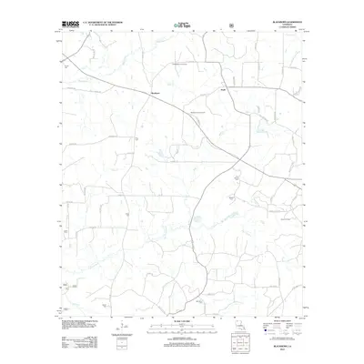
2012 Map of Blackburn
USGS Topo · Published 2012About this map
Blackburn and Ruple anchor this rural landscape in Claiborne Parish, where the local economy and geography are defined by the timber and energy industries. The terrain is deeply etched by a dense network of watercourses, including Flat Lick Bayou, Caney Cr, and Buck Cr, which feed into the larger Black Bayou system. This 2012 survey illustrates the continued importance of the East Blackburn Gas Field and the Homer Oil Field, with specialized access roads like Homer Oilfield Rd and Line Rd servicing the area. For those tracing local family histories, the sheet is exceptionally detailed, documenting numerous burial grounds such as Gryder Cem, King Cem, Cold Spring Cem, and Bethlehem Cem. The Blackburn Lookout Tower stands as a prominent landmark overlooking the intersection of St Spur 534 and the many winding parish roads that connect these small, enduring North Louisiana communities.
Find a feature on this map
60 named features on this map. Tap any name to fly to it.
Don’t see what you’re looking for? This feature index may not catch every label — zoom into the map to look around manually.
Map Details
Editions of this 2012 Blackburn Map
This is the sole edition of this map. No revisions or reprints were ever made.
Other maps of this area

1922 · Sarepta
USGS Topo · 1:62,500

1924 · Sarepta
USGS Topo · 1:62,500

1947 · Minden
USGS Topo · 1:62,500

1949 · Minden
USGS Topo · 1:62,500

1949 · Gibsland
USGS Topo · 1:62,500

1950 · Gibsland
USGS Topo · 1:62,500

1952 · Homer
USGS Topo · 1:62,500

1955 · Shreveport
USGS Topo · 1:250,000

1956 · Shreveport
USGS Topo · 1:250,000

1956 · Sarepta
USGS Topo · 1:62,500