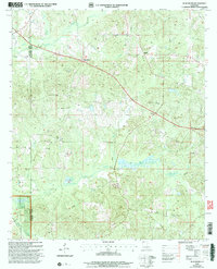
2003 Map of Blackburn
USGS Topo · Published 2005About this map
Blackburn and Ruple anchor the northern landscape of this North Louisiana territory, which is defined by the dense forest management of the Kisatchie National Forest. The terrain is deeply carved by a network of waterways including Black Creek, Sand Creek, and the winding Flat Lick Bayou, suggesting a landscape historically shaped by timber and water access. Resource extraction is evident through several marked Gravel Pits and an Oil Field, while a prominent Lookout Tower stands as a sentinel over the wooded hills. For genealogists, several small Cem locations are noted across the quadrangle, reflecting the dispersed rural settlement patterns typical of the Claiborne Parish and Webster Parish border. Modern infrastructure is represented by a significant Pipeline corridor cutting diagonally across the topography, alongside the winding path of La 518.
Find a feature on this map
18 named features on this map. Tap any name to fly to it.
Don’t see what you’re looking for? This feature index may not catch every label — zoom into the map to look around manually.
Map Details
Editions of this 2003 Blackburn Map
This is the sole edition of this map. No revisions or reprints were ever made.
Other maps of this area

1922 · Sarepta
USGS Topo · 1:62,500

1924 · Sarepta
USGS Topo · 1:62,500

1947 · Minden
USGS Topo · 1:62,500

1949 · Minden
USGS Topo · 1:62,500

1949 · Gibsland
USGS Topo · 1:62,500

1950 · Gibsland
USGS Topo · 1:62,500

1952 · Homer
USGS Topo · 1:62,500

1955 · Shreveport
USGS Topo · 1:250,000

1956 · Shreveport
USGS Topo · 1:250,000

1956 · Sarepta
USGS Topo · 1:62,500