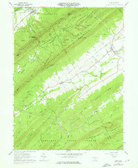
1960 Map of Blain
USGS Topo · Published 1976About this map
Tuscarora Mountain dominates the northwestern horizon of this Pennsylvania landscape, where the ridges and valleys of Toboyne and Jackson townships meet. The agricultural and timbered character of the mid-20th century is evident in the dense network of ridges, including Trostle Ridge and Amberson Ridge, which channel local life toward the valley floor settlements. Small villages such as Blain and New Germantown serve as historical anchors, connected by winding roads that track alongside Sherman Creek and Conodochueague Creek.
Find a feature on this map
44 named features on this map. Tap any name to fly to it.
Don’t see what you’re looking for? This feature index may not catch every label — zoom into the map to look around manually.
Map Details
Editions of this 1960 Blain Map
4 editions found
Other maps of this area

1919 · Newville
USGS Topo · 1:62,500

1919 · Mattawana
USGS Topo · 1:62,500

1923 · Shippensburg
USGS Topo · 1:62,500

1930 · Loysville
USGS Topo · 1:62,500

1933 · Loysville
USGS Topo · 1:62,500

1936 · East Waterford
USGS Topo · 1:48,000

1941 · East Waterford
USGS Topo · 1:62,500

1943 · Shippensburg
USGS Topo · 1:62,500

1945 · Newville
USGS Topo · 1:62,500

1945 · Shippensburg
USGS Topo · 1:62,500