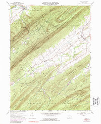
1960 Map of Blain
USGS Topo · Published 1988About this map
Tuscarora Mountain and Conococheague Mountain dominate the skyline of this central Pennsylvania landscape, creating the deep valleys of Horse Valley and Kettle Valley. The topographic pattern reveals a classic Appalachian ridge-and-valley formation, where agricultural settlements like Blain and New Germantown are concentrated in the lower, broader basins. Small rural gathering points such as Mt Pleasant and Center Square are linked by a network of local routes including Orchard Road and Kansas Valley Road, showing a community structure largely defined by the orientation of the surrounding ridges.
Find a feature on this map
52 named features on this map. Tap any name to fly to it.
Don’t see what you’re looking for? This feature index may not catch every label — zoom into the map to look around manually.
Map Details
Editions of this 1960 Blain Map
4 editions found
Other maps of this area

1919 · Newville
USGS Topo · 1:62,500

1919 · Mattawana
USGS Topo · 1:62,500

1923 · Shippensburg
USGS Topo · 1:62,500

1930 · Loysville
USGS Topo · 1:62,500

1933 · Loysville
USGS Topo · 1:62,500

1936 · East Waterford
USGS Topo · 1:48,000

1941 · East Waterford
USGS Topo · 1:62,500

1943 · Shippensburg
USGS Topo · 1:62,500

1945 · Newville
USGS Topo · 1:62,500

1945 · Shippensburg
USGS Topo · 1:62,500