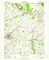
1961 Map of Blanchester
USGS Topo · Published 1962About this map
The intersection of the Baltimore and Ohio railroad corridors defines the development of this Clinton County landscape in the early 1960s. Blanchester serves as the primary hub, where industrial footprints like the Sewage Disposal plant and several municipal reservoirs suggest a period of mid-century infrastructure growth. The surrounding rural townships of Marion and Jefferson maintain a dense network of family-named roads, including Nauvoo Road and Kubeler Road, which connect isolated farmsteads to smaller rail-side hamlets like Midland and Westboro.
Find a feature on this map
63 named features on this map. Tap any name to fly to it.
Don’t see what you’re looking for? This feature index may not catch every label — zoom into the map to look around manually.
Map Details
Editions of this 1961 Blanchester Map
4 editions found

Other maps of this area

1907 · Blanchester
USGS Topo · 1:62,500

1914 · Batavia
USGS Topo · 1:48,000

1914 · Morrow
USGS Topo · 1:62,500

1916 · Batavia
USGS Topo · 1:62,500

1916 · Morrow
USGS Topo · 1:62,500

1917 · Sardinia
USGS Topo · 1:62,500

1944 · Sardinia
USGS Topo · 1:62,500

1947 · Columbus
USGS Topo · 1:250,000

1953 · Newtonsville
USGS Topo · 1:24,000

1953 · Cincinnati
USGS Topo · 1:250,000