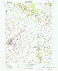
1961 Map of Blanchester
USGS Topo · Published 1976About this map
The Baltimore and Ohio Railroad serves as the industrial backbone of this Clinton County landscape, connecting the clustered settlements of Blanchester and Midland with Westboro. These rail towns are surrounded by a patchwork of small-scale agriculture and woodlots, punctuated by historical landmarks like the Indian Mound near Todd Fork. The cultural geography of the era is preserved through numerous family and institutional burial grounds, including Rehoboth Cem, Moore-Johns Cem, and the IOOF Cem south of Westboro.
Find a feature on this map
69 named features on this map. Tap any name to fly to it.
Don’t see what you’re looking for? This feature index may not catch every label — zoom into the map to look around manually.
Map Details
Editions of this 1961 Blanchester Map
4 editions found

Other maps of this area

1907 · Blanchester
USGS Topo · 1:62,500

1914 · Batavia
USGS Topo · 1:48,000

1914 · Morrow
USGS Topo · 1:62,500

1916 · Batavia
USGS Topo · 1:62,500

1916 · Morrow
USGS Topo · 1:62,500

1917 · Sardinia
USGS Topo · 1:62,500

1944 · Sardinia
USGS Topo · 1:62,500

1947 · Columbus
USGS Topo · 1:250,000

1953 · Newtonsville
USGS Topo · 1:24,000

1953 · Cincinnati
USGS Topo · 1:250,000