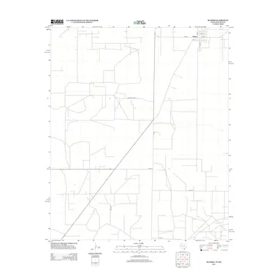
2012 Map of Bledsoe
USGS Topo · Published 2012About this map
Bledsoe anchors this West Texas landscape near the New Mexico border, where the grid of the Llano Estacado meets the diagonal path of FM-769. This 2012 survey illustrates a region defined by extensive agricultural and ranching infrastructure, with a network of rural routes such as S Roosevelt Road A and Cord-176 connecting dispersed properties. The town center itself is concentrated along FM-595, with local thoroughfares like Filmore St and 2nd St forming the community's primary residential core. The survey reveals how transportation remains the lifeline of this high plains area, with FM-1585 and Brown Ln providing access to the wide-open reaches south of the settlement.
Find a feature on this map
12 named features on this map. Tap any name to fly to it.
Don’t see what you’re looking for? This feature index may not catch every label — zoom into the map to look around manually.
Map Details
Editions of this 2012 Bledsoe Map
This is the sole edition of this map. No revisions or reprints were ever made.
Other maps of this area

1954 · Brownfield
USGS Topo · 1:250,000

1958 · Brownfield
USGS Topo · 1:250,000

1962 · Brownfield
USGS Topo · 1:250,000

1970 · Bronco NE
USGS Topo · 1:24,000

1970 · Walking Cane Ranch
USGS Topo · 1:24,000

1970 · Bledsoe
USGS Topo · 1:24,000

1970 · Morton SW
USGS Topo · 1:24,000

1970 · Morton NW
USGS Topo · 1:24,000

1970 · Bledsoe NE
USGS Topo · 1:24,000
1971 · Two B Ranch NW
USGS Topo · 1:24,000