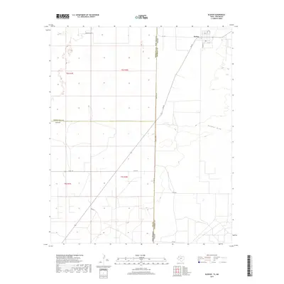
2019 Map of Bledsoe
USGS Topo · Published 2019About this map
The small community of Bledsoe anchors this high-plains landscape along the West Texas and New Mexico border. Situated in Cochran County, the settlement is organized around a grid of streets including Filmore St, N Buchanan St, and 2nd St, with a central Po serving the local residents. The geography is defined by the ephemeral path of Sulphur Draw, which meanders across the eastern half of the quadrangle, illustrating the subtle drainage patterns of the Llano Estacado. A network of farm-to-market roads and county routes, such as FM 769 and Co Rd 176, connect the dispersed farmsteads and agricultural sections. The map clearly delineates the jurisdictional boundary at State Line Rd, where Texas meets Roosevelt and Lea Counties in New Mexico, marking a transition between the distinct survey systems and road networks of the two states.
Find a feature on this map
24 named features on this map. Tap any name to fly to it.
Don’t see what you’re looking for? This feature index may not catch every label — zoom into the map to look around manually.
Map Details
Editions of this 2019 Bledsoe Map
This is the sole edition of this map. No revisions or reprints were ever made.
Other maps of this area

1954 · Brownfield
USGS Topo · 1:250,000

1958 · Brownfield
USGS Topo · 1:250,000

1962 · Brownfield
USGS Topo · 1:250,000

1970 · Bronco NE
USGS Topo · 1:24,000

1970 · Walking Cane Ranch
USGS Topo · 1:24,000

1970 · Bledsoe
USGS Topo · 1:24,000

1970 · Morton SW
USGS Topo · 1:24,000

1970 · Morton NW
USGS Topo · 1:24,000

1970 · Bledsoe NE
USGS Topo · 1:24,000
1971 · Two B Ranch NW
USGS Topo · 1:24,000