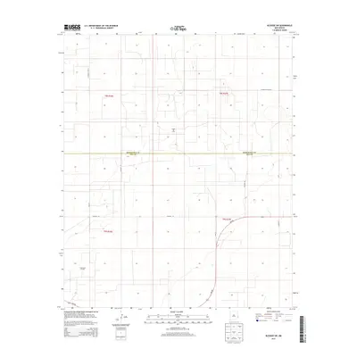
2013 Map of Bledsoe SW
USGS Topo · Published 2013About this map
The High Plains borderlands of eastern New Mexico are defined here by a geometric grid of rural transit and petroleum extraction. Centered on the boundary between Roosevelt Co and Lea Co, the landscape is partitioned into townships like t8s r36e and t9s r37e. The map documents a sparse, industrial geography where the Allison Oil Field and Crossroads Oil Field signal the region's economic drivers. Transportation is largely confined to a rigid network of county roads, including Co Road 173 and S Roosevelt Road L, which serve isolated ranching or drilling operations. A notable departure from the cardinal grid is the sweeping curve of Nm-508, which provides the primary paved artery through the southern half of the quadrangle near Howe Ln.
Find a feature on this map
15 named features on this map. Tap any name to fly to it.
Don’t see what you’re looking for? This feature index may not catch every label — zoom into the map to look around manually.
Map Details
Editions of this 2013 Bledsoe SW Map
This is the sole edition of this map. No revisions or reprints were ever made.
Other maps of this area

1954 · Brownfield
USGS Topo · 1:250,000

1958 · Brownfield
USGS Topo · 1:250,000

1962 · Brownfield
USGS Topo · 1:250,000

1970 · Bronco NE
USGS Topo · 1:24,000

1970 · Walking Cane Ranch
USGS Topo · 1:24,000

1970 · Ranger Lake
USGS Topo · 1:24,000

1970 · Bledsoe
USGS Topo · 1:24,000

1970 · Bledsoe NE
USGS Topo · 1:24,000

1972 · Bluit
USGS Topo · 1:24,000
1972 · Bledsoe SW
USGS Topo · 1:24,000