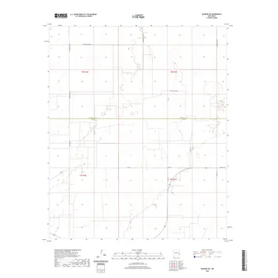
2020 Map of Bledsoe SW
USGS Topo · Published 2020About this map
The Roosevelt Co Lea Co boundary line divides this High Plains landscape, marking a transition between the northern agricultural reaches and the southern petroleum-rich sections of New Mexico. In this 2020 survey, the land is etched with a strictly linear grid of rural infrastructure, where S Roosevelt Road 44 and S Roosevelt Road 45 define the township and range divisions. The network of local routes, including Baldridge Rd and Bilbrey Rd, connects isolated parcels and ranching interests across the semi-arid terrain. Researchers can trace the development of this borderland by observing the path of Co Rd 173 as it meanders through the landscape, a contrast to the rigid cardinal-direction road system of the Roosevelt County panhandle. This map captures the modern spatial organization of a territory defined by large-scale land management and the sparse, vital connections of the Llano Estacado.
Find a feature on this map
16 named features on this map. Tap any name to fly to it.
Don’t see what you’re looking for? This feature index may not catch every label — zoom into the map to look around manually.
Map Details
Editions of this 2020 Bledsoe SW Map
This is the sole edition of this map. No revisions or reprints were ever made.
Other maps of this area

1954 · Brownfield
USGS Topo · 1:250,000

1958 · Brownfield
USGS Topo · 1:250,000

1962 · Brownfield
USGS Topo · 1:250,000

1970 · Bronco NE
USGS Topo · 1:24,000

1970 · Walking Cane Ranch
USGS Topo · 1:24,000

1970 · Ranger Lake
USGS Topo · 1:24,000

1970 · Bledsoe
USGS Topo · 1:24,000

1970 · Bledsoe NE
USGS Topo · 1:24,000

1972 · Bluit
USGS Topo · 1:24,000
1972 · Bledsoe SW
USGS Topo · 1:24,000