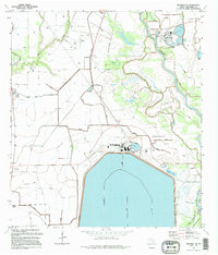
1995 Map of Blessing SE
USGS Topo · Published 1995About this map
The industrial and riparian landscape of Matagorda County takes center stage in this mid-1990s study, dominated by the massive Nuclear Generation Facility and its associated infrastructure. This facility, equipped with an Atmospheric Monitoring Tower and Visitor Center, sits adjacent to a vast water system south of the Colorado River. The map captures a complex network of Levees, Siphons, and a lingering Old Railroad Grade that speaks to the region's historical transport and water management needs. Evidence of earlier settlement remains at Ashby (Site) and the small community of Tin Top, while the Port of Bay City and nearby Lake Le Tulle anchor the northern reaches. Along the river, names like Selkirk Island and Exotic Isle reflect the unique geography of the Texas Gulf Coast as the river winds toward the West Branch.
Find a feature on this map
36 named features on this map. Tap any name to fly to it.
Don’t see what you’re looking for? This feature index may not catch every label — zoom into the map to look around manually.
Map Details
Editions of this 1995 Blessing SE Map
This is the sole edition of this map. No revisions or reprints were ever made.
Other maps of this area

1951 · Bay City
USGS Topo · 1:250,000

1952 · Matagorda
USGS Topo · 1:24,000

1952 · Blessing SE
USGS Topo · 1:24,000

1952 · Palacios
USGS Topo · 1:24,000

1952 · Blessing
USGS Topo · 1:24,000

1952 · Bay City
USGS Topo · 1:24,000

1952 · Markham
USGS Topo · 1:24,000

1952 · Midfield
USGS Topo · 1:24,000

1952 · Palacios NE
USGS Topo · 1:24,000

1952 · Wadsworth
USGS Topo · 1:24,000