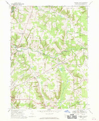
1967 Map of Blooming Valley
USGS Topo · Published 1970About this map
Blooming Valley serves as a central hub for Crawford County agricultural life in the late 1960s, surrounded by a patchwork of small townships including Woodcock, Richmond, and East Mead. The landscape is defined by the winding course of Woodcock Creek and the southern reaches of French Creek, where the Erie-Lackawanna railroad skirts the northwestern corner. Local landmarks like the Woodcock Grange and the Fairgrounds near Meadville reflect the area's rural social fabric. Genealogists will find a wealth of specific local history in the numerous named burial grounds and houses of worship, such as Mt Blair Cem & Ch, Townley Cem, and State Road Ch. The presence of several Gravel Pits and intersections like Fountain House Corners and Delamater Corners provide fine-grained detail for researchers tracing family holdings or the development of historic crossroads communities during this era of Pennsylvania's growth.
Find a feature on this map
41 named features on this map. Tap any name to fly to it.
Don’t see what you’re looking for? This feature index may not catch every label — zoom into the map to look around manually.
Map Details
Editions of this 1967 Blooming Valley Map
4 editions found
Other maps of this area

1923 · Meadville
USGS Topo · 1:62,500

1923 · Cambridge Springs
USGS Topo · 1:62,500

1925 · Meadville
USGS Topo · 1:62,500

1925 · Cambridge Springs
USGS Topo · 1:62,500

1927 · Townville
USGS Topo · 1:48,000

1929 · Union City
USGS Topo · 1:62,500

1932 · Townville
USGS Topo · 1:62,500

1932 · Union City
USGS Topo · 1:62,500

1943 · Meadville
USGS Topo · 1:62,500

1943 · Cambridge Springs
USGS Topo · 1:62,500