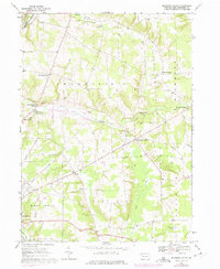
1967 Map of Blooming Valley
USGS Topo · Published 1975About this map
Blooming Valley serves as a central hub in this mid-1960s survey of Crawford County, illustrating a landscape defined by the transition from traditional agriculture to a regulated water system. The most significant topographical change is the presence of Woodcock Creek Lake, a project that altered the course of Woodcock Creek and submerged large portions of the valley floor. Rural community life is anchored by family-named landmarks like Pinney Corners and Fountain House Corners, while the Fairgrounds near the western border points to the importance of regional gatherings. The Erie-Lackawanna railroad line cuts across the northwestern corner, following the path of French Creek. This map preserves the locations of numerous small burial grounds and houses of worship, including Mt Blair Cem and the Pleasant Valley Ch, many of which sit on the periphery of the new reservoir boundary.
Find a feature on this map
36 named features on this map. Tap any name to fly to it.
Don’t see what you’re looking for? This feature index may not catch every label — zoom into the map to look around manually.
Map Details
Editions of this 1967 Blooming Valley Map
4 editions found
Other maps of this area

1923 · Meadville
USGS Topo · 1:62,500

1923 · Cambridge Springs
USGS Topo · 1:62,500

1925 · Meadville
USGS Topo · 1:62,500

1925 · Cambridge Springs
USGS Topo · 1:62,500

1927 · Townville
USGS Topo · 1:48,000

1929 · Union City
USGS Topo · 1:62,500

1932 · Townville
USGS Topo · 1:62,500

1932 · Union City
USGS Topo · 1:62,500

1943 · Meadville
USGS Topo · 1:62,500

1943 · Cambridge Springs
USGS Topo · 1:62,500