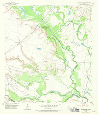
1952 Map of Bloomington SW
USGS Topo · Published 1970About this map
The Guadalupe River and San Antonio River converge in this low-lying coastal landscape, defining a complex network of bayous and drainage systems. Industrial activity is pervasive throughout the mid-century terrain, marked by the extensive Heyser Oil Field and numerous Oil Wells and tanks connected by a Pipe Line. The Missouri Pacific railroad cuts diagonally across the northern portion of the quadrangle, facilitating the transport of resources from this productive energy corridor.
Find a feature on this map
27 named features on this map. Tap any name to fly to it.
Don’t see what you’re looking for? This feature index may not catch every label — zoom into the map to look around manually.
Map Details
Editions of this 1952 Bloomington SW Map
4 editions found
Other maps of this area

1951 · Bloomington
USGS Topo · 1:24,000

1952 · Tivoli
USGS Topo · 1:24,000

1952 · Bloomington SW
USGS Topo · 1:24,000

1952 · Austwell
USGS Topo · 1:24,000

1952 · Placedo
USGS Topo · 1:24,000

1952 · Green Lake
USGS Topo · 1:24,000

1953 · Beeville
USGS Topo · 1:250,000

1954 · Vidaurri
USGS Topo · 1:62,500

1956 · Beeville
USGS Topo · 1:250,000

1960 · Beeville
USGS Topo · 1:250,000