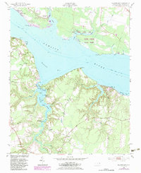
1953 Map of Blounts Bay
USGS Topo · Published 1983About this map
The wide Pamlico River dominates this mid-century survey, dividing the landscape into distinct shoreline communities. On the north bank, the Washington Yacht and Country Club and the residential area of River Acres mark the development near the river's bend, while the expansive Goose Creek State Park preserves the tidal wetlands around Little Goose Creek. This area illustrates the transition from mid-century leisure sites like Camp Leach and Camp Hardee to the burgeoning suburban character of Shady Banks.
Find a feature on this map
59 named features on this map. Tap any name to fly to it.
Don’t see what you’re looking for? This feature index may not catch every label — zoom into the map to look around manually.
Map Details
Editions of this 1953 Blounts Bay Map
5 editions found

Other maps of this area

1902 · Vanceboro
USGS Topo · 1:62,500

1903 · Chocowinity
USGS Topo · 1:62,500

1904 · Vanceboro
USGS Topo · 1:62,500

1905 · Chocowinity
USGS Topo · 1:62,500

1905 · Vanceboro
USGS Topo · 1:62,500

1943 · Plymouth
USGS Topo · 1:125,000

1950 · Pinetown
USGS Topo · 1:24,000

1950 · Aurora
USGS Topo · 1:24,000

1950 · Edward
USGS Topo · 1:24,000

1951 · Bunyan
USGS Topo · 1:24,000