
1961 Map of Blue
USGS Topo · Published 1963About this map
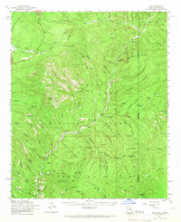
Blue River carves a deep path through this section of the Apache National Forest, defining the remote geography along the Arizona New Mexico border. The settlement of Blue and the nearby Blue Ranger Sta serve as the primary human hubs in a landscape dominated by the high Mogollon Rim. Small outposts and landmarks like Carlton Vista, Cosper, and Jackson Box are scattered throughout the river valley and its adjacent canyons. The terrain is marked by significant elevation changes, from the Blue Springs in the north to the Bear Mtn Lookout and Auger Peak in the south. Notable water sources such as Cleveland Spr, Cedar Spring, and Milligan Lake provide critical points of interest for those studying the water usage and ranching history of this high-country region.
Find a feature on this map
129 named features on this map. Tap any name to fly to it.
Don’t see what you’re looking for? This feature index may not catch every label — zoom into the map to look around manually.
Map Details
Editions of this 1961 Blue Map
2 editions found
Other maps of this area

1910 · Mogollon
USGS Topo · 1:125,000

1912 · Mogollon
USGS Topo · 1:125,000

1913 · Morenci
USGS Topo · 1:125,000

1915 · Morenci
USGS Topo · 1:125,000

1915 · Reserve
USGS Topo · 1:125,000

1918 · Reserve
USGS Topo · 1:125,000

1922 · Nutrioso
USGS Topo · 1:125,000

1954 · Clifton
USGS Topo · 1:250,000

1957 · Clifton
USGS Topo · 1:250,000

1958 · Clifton
USGS Topo · 1:250,000