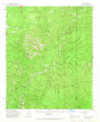
1961 Map of Blue
USGS Topo · Published 1966About this map
The Blue River carves a deep path through this remote portion of the Apache National Forest, defining a landscape where the Mogollon Rim meets the Arizona-New Mexico border. In the early 1960s, the small settlement of Blue served as a focal point for the surrounding canyon country, supported by the Blue Ranger Sta and scattered homesteads like Cosper and Nolan. The geography is defined by high mesas and deep drainages, including KP Mesa and Box Canyon, with the Blue River valley providing the primary corridor for movement. High-altitude landmarks such as Bear Mtn Lookout and Maness Peak overlook the complex system of creeks, including Campbell Blue Creek and Pueblo Creek, that feed the river system during this era of forest management and isolated ranching.
Find a feature on this map
109 named features on this map. Tap any name to fly to it.
Don’t see what you’re looking for? This feature index may not catch every label — zoom into the map to look around manually.
Map Details
Editions of this 1961 Blue Map
2 editions found

Other maps of this area

1910 · Mogollon
USGS Topo · 1:125,000

1912 · Mogollon
USGS Topo · 1:125,000

1913 · Morenci
USGS Topo · 1:125,000

1915 · Morenci
USGS Topo · 1:125,000

1915 · Reserve
USGS Topo · 1:125,000

1918 · Reserve
USGS Topo · 1:125,000

1922 · Nutrioso
USGS Topo · 1:125,000

1954 · Clifton
USGS Topo · 1:250,000

1957 · Clifton
USGS Topo · 1:250,000

1958 · Clifton
USGS Topo · 1:250,000