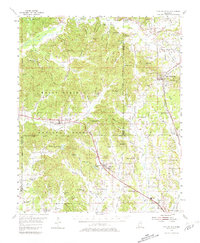
1955 Map of Blue Mountain
USGS Topo · Published 1981About this map
Blue Mountain and Hickory Flat serve as the primary hubs in this mid-century survey of the north Mississippi hill country. The landscape is defined by the extensive Holly Springs National Forest, where a dense network of small family-named landmarks like Richmond Hollow, Avery Hollow, and Jobs Hollow reveals the deep-rooted rural settlement patterns of Tippah and Benton Counties. The Gulf Mobile and Ohio and St Louis - San Francisco railroads provide the industrial backbone, connecting small communities such as Cotton Plant and Cornersville to larger markets.
Find a feature on this map
96 named features on this map. Tap any name to fly to it.
Don’t see what you’re looking for? This feature index may not catch every label — zoom into the map to look around manually.
Map Details
Editions of this 1955 Blue Mountain Map
3 editions found

Other maps of this area

1942 · Denmark
USGS Topo · 1:62,500

1943 · Denmark
USGS Topo · 1:62,500

1944 · Potts Camp
USGS Topo · 1:62,500

1945 · Potts Camp
USGS Topo · 1:62,500

1949 · New Albany
USGS Topo · 1:62,500

1950 · Ashland
USGS Topo · 1:62,500

1951 · New Albany
USGS Topo · 1:62,500

1951 · Walnut
USGS Topo · 1:62,500

1953 · Holly Springs
USGS Topo · 1:62,500

1955 · Ripley
USGS Topo · 1:62,500