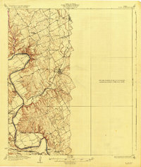
1927 Map of Blum
USGS Topo · Published 1927About this map
The Brazos River carves a winding path through the center of this 1920s landscape, defining the boundaries of Johnson, Hill, and Bosque counties. A complex network of river crossings and hollows characterizes the terrain, with family-named landmarks like Robison Bluff and Broken Rock Hollow providing reference points for early twentieth-century residents. The settlement of Blum serves as a central hub where the Gulf Colorado and Santa Fe RR crosses the Nolan River. Local life centers around a series of rural education outposts, including Plainview School, Live Oak School, and Steiner Valley School. Before modern bridging, river transit relied on identified points such as Helps Crossing and Powell Crossing. These landmarks, along with the Heath Cem, offer a detailed look at the social and physical infrastructure of this Central Texas region during the mid-1920s.
Find a feature on this map
34 named features on this map. Tap any name to fly to it.
Don’t see what you’re looking for? This feature index may not catch every label — zoom into the map to look around manually.
Map Details
Editions of this 1927 Blum Map
2 editions found

Other maps of this area

1888 · Meridian
USGS Topo · 1:125,000

1889 · Granbury
USGS Topo · 1:125,000

1891 · Cleburne
USGS Topo · 1:125,000

1892 · Waco
USGS Topo · 1:125,000

1894 · Meridian
USGS Topo · 1:125,000

1894 · Cleburne
USGS Topo · 1:125,000

1920 · Waco
USGS Topo · 1:125,000

1924 · Cleburne 3-B
USGS Topo · 1:48,000

1924 · Waco 2-b
USGS Topo · 1:48,000

1924 · Cleburne 3-C
USGS Topo · 1:48,000