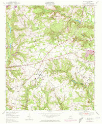
1948 Map of Blythe
USGS Topo · Published 1973About this map
Blythe sits at the junction of several historic thoroughfares, including the Louisville Road and Keysville Road, serving as a central point of settlement along the border of Richmond and Burke counties. The landscape is heavily influenced by the presence of the Fort Gordon Military Reservation, which occupies the northern third of the map. This military presence contrasts with the traditional rural life evidenced by numerous country churches such as Spring Grove Church and Brown Grove Church. The Central of Georgia railroad cuts through the terrain, connecting small hubs like Ellwood to the larger region. Local family history is preserved in several small burial grounds, including Saxon Cemetery and Rachels Cemetery, while the economy is tied to the numerous water bodies like Lower Leitner Pond and Union Mill Pond.
Find a feature on this map
41 named features on this map. Tap any name to fly to it.
Don’t see what you’re looking for? This feature index may not catch every label — zoom into the map to look around manually.
Map Details
Editions of this 1948 Blythe Map
4 editions found
Other maps of this area

1919 · Gough
USGS Topo · 1:62,500

1920 · Stapleton
USGS Topo · 1:62,500

1922 · Harlem
USGS Topo · 1:62,500

1922 · Hephzibah
USGS Topo · 1:62,500

1948 · Hephzibah
USGS Topo · 1:62,500

1948 · Harlem
USGS Topo · 1:62,500

1948 · Stapleton
USGS Topo · 1:62,500

1948 · Gough
USGS Topo · 1:62,500

1948 · Blythe
USGS Topo · 1:24,000

1948 · Harlem
USGS Topo · 1:24,000