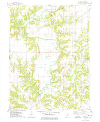
1974 Map of Blyton
USGS Topo · Published 1978About this map
The meandering Spoon River dominates this mid-1970s landscape, winding through a series of dramatic bluffs and valleys that separate the high agricultural plateaus of Deerfield and Lee townships. The topography is defined by deep incisions from tributaries like Turkey Creek and Shoal Creek, creating a complex network of ridges where many of the area’s oldest features are located. Small, rural focal points such as Babylon and Blyton serve as markers of the region's historical settlement pattern, which was largely dictated by the river’s path and the available crossings.
Find a feature on this map
25 named features on this map. Tap any name to fly to it.
Don’t see what you’re looking for? This feature index may not catch every label — zoom into the map to look around manually.
Map Details
Editions of this 1974 Blyton Map
2 editions found
Other maps of this area

1912 · Canton
USGS Topo · 1:62,500

1915 · Avon
USGS Topo · 1:62,500

1918 · Vermont
USGS Topo · 1:62,500

1921 · Vermont
USGS Topo · 1:62,500

1925 · Havana
USGS Topo · 1:62,500

1944 · Avon
USGS Topo · 1:62,500

1947 · Lewistown
USGS Topo · 1:24,000

1947 · Adair
USGS Topo · 1:24,000

1948 · Lewistown
USGS Topo · 1:24,000
1948 · Adair
USGS Topo · 1:24,000