
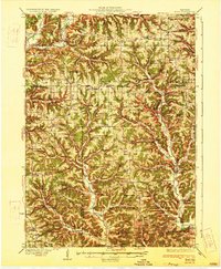
1933 Map of Boaz
USGS Topo · Published 1933About this map
The Kickapoo River valley and its intricate network of tributary hollows define this corner of the Driftless Area during the early 1930s. The landscape is intensely divided by high ridges like Ash Ridge and Sylvan Ridge, which dictated the placement of small, localized communities. This era of settlement is marked by an extraordinary density of rural infrastructure, with dozens of one-room schoolhouses such as Manning School and Eckleberry School serving isolated families.
Find a feature on this map
114 named features on this map. Tap any name to fly to it.
Don’t see what you’re looking for? This feature index may not catch every label — zoom into the map to look around manually.
Map Details
Editions of this 1933 Boaz Map
2 editions found
Other maps of this area

1905 · Richland Center
USGS Topo · 1:125,000

1923 · Viroqua
USGS Topo · 1:62,500

1924 · Gays Mills
USGS Topo · 1:62,500

1926 · Gays Mills
USGS Topo · 1:62,500

1926 · Viroqua
USGS Topo · 1:62,500

1926 · La Farge
USGS Topo · 1:62,500

1926 · Wauzeka
USGS Topo · 1:62,500

1927 · Hillsboro
USGS Topo · 1:62,500

1933 · Boscobel
USGS Topo · 1:62,500

1958 · La Crosse
USGS Topo · 1:250,000