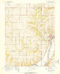
1951 Map of Bonner Springs
USGS Topo · Published 1951About this map
Bonner Springs serves as the focal point of this mid-century landscape, situated where the Kansas River cuts through the border of Wyandotte and Johnson counties. The area is characterized by a dense network of local education and community sites, including several rural schools such as Coal Ridge Sch, Glenwood Sch, and Twist Sch that dot the townships of Fairmount and Delaware. In the southern reaches, the settlement of Loring sits tucked against the Union Pacific tracks, while the Atchison Topeka and Santa Fe railroad follows the opposite bank of the river through Frisbie. The topography is defined by the winding paths of Wolf Creek and Little Kaw Creek, which carve through the uplands before joining the main river valley. Scattered gas wells in the northern sections and a large Quarry near the river highlight the era's local resource extraction.
Find a feature on this map
38 named features on this map. Tap any name to fly to it.
Don’t see what you’re looking for? This feature index may not catch every label — zoom into the map to look around manually.
Map Details
Editions of this 1951 Bonner Springs Map
2 editions found
Other maps of this area

1885 · Lawrence
USGS Topo · 1:125,000

1886 · Oskaloosa
USGS Topo · 1:125,000

1887 · Olathe
USGS Topo · 1:125,000

1888 · Oskaloosa
USGS Topo · 1:125,000

1889 · Lawrence
USGS Topo · 1:125,000

1890 · Kansas City
USGS Topo · 1:125,000

1893 · Olathe
USGS Topo · 1:125,000

1894 · Kansas City
USGS Topo · 1:125,000

1894 · Oskaloosa
USGS Topo · 1:125,000

1934 · Bonner Springs
USGS Topo · 1:48,000