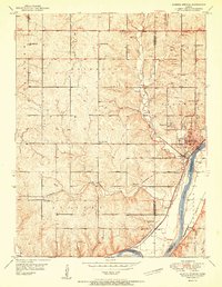
1951 Map of Bonner Springs
USGS Topo · Published 1951About this map
The Kansas River dictates the landscape of this 1950s survey, where the river valley serves as a bustling corridor for the Atchison Topeka and Santa Fe and Union Pacific railroads. The town of Bonner Springs sits at a critical junction of these rail lines and river bends, supported by local industry like the Quarry and numerous Gas Wells dotting the northern bluffs. Beyond the valley, the terrain is defined by a dense network of country schools that served the surrounding townships, including Coal Ridge Sch, Elm Grove Sch, and Walker Sch. The presence of several burial grounds, such as Riverview Cem and Lenape Cem, provides valuable points of reference for genealogists tracing families in the Sherman and Delaware areas during this post-war era of Kansas development.
Find a feature on this map
34 named features on this map. Tap any name to fly to it.
Don’t see what you’re looking for? This feature index may not catch every label — zoom into the map to look around manually.
Map Details
Editions of this 1951 Bonner Springs Map
2 editions found
Other maps of this area

1885 · Lawrence
USGS Topo · 1:125,000

1886 · Oskaloosa
USGS Topo · 1:125,000

1887 · Olathe
USGS Topo · 1:125,000

1888 · Oskaloosa
USGS Topo · 1:125,000

1889 · Lawrence
USGS Topo · 1:125,000

1890 · Kansas City
USGS Topo · 1:125,000

1893 · Olathe
USGS Topo · 1:125,000

1894 · Kansas City
USGS Topo · 1:125,000

1894 · Oskaloosa
USGS Topo · 1:125,000

1934 · Bonner Springs
USGS Topo · 1:48,000