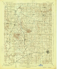
1902 Map of Boonville
USGS Topo · Published 1925About this map
Boonville serves as the primary hub in this turn-of-the-century landscape, where the Southern RR and the Indianapolis and Evansville RR converge to shape the local economy. The map reveals a transition from water-based transport to rail, most notably evidenced by the abandoned canal snaking through Campbell township near Millersburg. This infrastructure, alongside the winding course of Pigeon Creek, dictates the placement of smaller settlements like Chandler, Elberfeld, and Lynnville. High ground is defined by distinct landmarks such as Big Ditney Hill and Little Ditney Hill, providing contrast to the low-lying drainage basins of Cypress Creek and Squaw Creek. The presence of numerous township boundaries, including Hart, Barton, and Greer, offers a clear look at the civic organization of Warrick County during this period of growth.
Find a feature on this map
53 named features on this map. Tap any name to fly to it.
Don’t see what you’re looking for? This feature index may not catch every label — zoom into the map to look around manually.
Map Details
Editions of this 1902 Boonville Map
4 editions found
Other maps of this area

1900 · De Gonia Springs
USGS Topo · 1:62,500

1901 · Owensboro
USGS Topo · 1:62,500

1901 · Princeton
USGS Topo · 1:62,500

1901 · Haubstadt
USGS Topo · 1:62,500

1902 · Ditney
USGS Topo · 1:125,000

1902 · Degonia Springs
USGS Topo · 1:62,500

1902 · Boonville
USGS Topo · 1:62,500

1903 · Velpen
USGS Topo · 1:62,500

1903 · Haubstadt
USGS Topo · 1:62,500

1903 · Petersburg
USGS Topo · 1:62,500