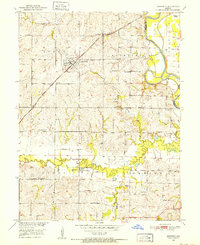
1951 Map of Bosworth
USGS Topo · Published 1952About this map
Bosworth serves as the primary rail hub on this mid-century survey, situated at the intersection of a local road network and the Atchison Topeka and Santa Fe railroad. The landscape is defined by the sweeping curves of the Grand River and Big Creek, which feed into complex wetlands like Potter Slough. This map reveals a high density of rural institutions that organized life in the early 1950s, including a significant number of country schools such as Guilford Sch, West Fairview Sch, and White Swan Sch. The cultural geography of the Combs and Dewitt townships is further detailed through several houses of worship and burial grounds, notably Rockford Ch and the Pleasant Park Cemetery. The drainage patterns of named tributaries like Parker Branch and Little Hurricane Creek highlight the dissected topography typical of the Missouri River Basin development era.
Find a feature on this map
30 named features on this map. Tap any name to fly to it.
Don’t see what you’re looking for? This feature index may not catch every label — zoom into the map to look around manually.
Map Details
Editions of this 1951 Bosworth Map
4 editions found
Other maps of this area

1890 · Marshall
USGS Topo · 1:125,000

1892 · Marshall
USGS Topo · 1:125,000

1901 · Marshall
USGS Topo · 1:125,000

1924 · Hale
USGS Topo · 1:62,500

1949 · Mendon
USGS Topo · 1:24,000

1950 · Hale
USGS Topo · 1:24,000

1951 · Hale
USGS Topo · 1:24,000

1951 · Bosworth
USGS Topo · 1:24,000

1951 · Miami
USGS Topo · 1:24,000

1951 · Brunswick West
USGS Topo · 1:24,000