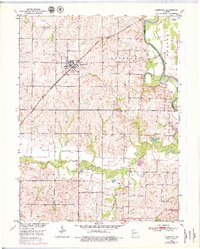
1951 Map of Bosworth
USGS Topo · Published 1979About this map
The settlement of Bosworth serves as the central hub of this mid-century Missouri landscape, where the Atchison Topeka and Santa Fe railroad cuts diagonally across the terrain. This topography is defined by the winding course of the Grand River to the east and the intricate drainage systems of Little Hurricane Creek and Big Creek. The map documents a rural society organized around small community anchors, such as Rockford Ch and several burial grounds, including Union Cem and Wharton Cem. A network of levees along the river and its tributaries indicates a significant investment in managing the bottomlands for agricultural use. While the higher ground is marked by ridges like Triplett and Rockford, the lower elevations feature distinctive water formations like Potter Slough and various branches including Snow Branch and Lick Branch.
Find a feature on this map
23 named features on this map. Tap any name to fly to it.
Don’t see what you’re looking for? This feature index may not catch every label — zoom into the map to look around manually.
Map Details
Editions of this 1951 Bosworth Map
4 editions found
Other maps of this area

1890 · Marshall
USGS Topo · 1:125,000

1892 · Marshall
USGS Topo · 1:125,000

1901 · Marshall
USGS Topo · 1:125,000

1924 · Hale
USGS Topo · 1:62,500

1949 · Mendon
USGS Topo · 1:24,000

1950 · Hale
USGS Topo · 1:24,000

1951 · Hale
USGS Topo · 1:24,000

1951 · Bosworth
USGS Topo · 1:24,000

1951 · Miami
USGS Topo · 1:24,000

1951 · Brunswick West
USGS Topo · 1:24,000