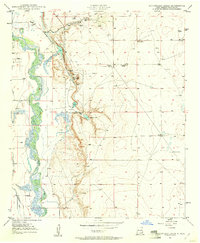
1950 Map of Bottomless Lakes
USGS Topo · Published 1961About this map
Bottomless Lakes State Park follows a dramatic escarpment where the high desert plateau drops toward the Pecos River valley. The map documents a series of sinkhole lakes along this bluff, including Lea Lake, Mirror Lake, and Inkwell Lake, which served as critical water sources in a landscape dominated by ranching and early petroleum exploration. The western portion of the sheet shows the complex hydrology of the river corridor, with the Hagerman Canal and various ditches supporting irrigation efforts in Chaves County. This 1950s-era topography also notes local social landmarks like the Fin and Feather Club and a network of family-held properties such as Ervin Ranch and Atkinson Ranch, illustrating the transition from open range to a more established agricultural and recreational landscape.
Find a feature on this map
22 named features on this map. Tap any name to fly to it.
Don’t see what you’re looking for? This feature index may not catch every label — zoom into the map to look around manually.
Map Details
Editions of this 1950 Bottomless Lakes Map
4 editions found
Other maps of this area

1949 · Wade Ranch
USGS Topo · 1:24,000

1949 · L-E Ranch
USGS Topo · 1:24,000

1950 · Dexter West
USGS Topo · 1:24,000

1950 · Comanche Spring
USGS Topo · 1:24,000

1950 · Bottomless Lakes
USGS Topo · 1:24,000

1950 · South Spring
USGS Topo · 1:24,000

1950 · Bitter Lake
USGS Topo · 1:24,000

1950 · Dexter East
USGS Topo · 1:24,000

1952 · Bar C Bar Ranch
USGS Topo · 1:24,000

1955 · Roswell
USGS Topo · 1:250,000