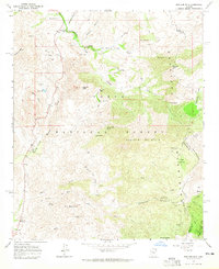
1964 Map of Boulder Mtn
USGS Topo · Published 1965About this map
The Mazatzal Mountains define the high country of this mid-1960s survey, where the rugged terrain of the Tonto National Forest meets the boundary of Gila and Maricopa counties. The settlement at Sunflower and the nearby Sunflower Campground serve as central points along the drainage of Sycamore Creek, which winds through the western portion of the map. Traces of historical land use are visible in the network of a Jeep Trail and a Pack Trail that navigate the ridges and canyons, connecting remote outposts like Boulder Bobs Cabin. Resource extraction is evidenced by the El Oso Mine and Jolene Mine in the southeast near Bull Basin, while the cattle industry's presence is marked by features such as the Diamond Ranch, Bushnell Sheep Tank, and various water tanks across Black Mesa and Round Valley.
Find a feature on this map
50 named features on this map. Tap any name to fly to it.
Don’t see what you’re looking for? This feature index may not catch every label — zoom into the map to look around manually.
Map Details
Editions of this 1964 Boulder Mtn Map
3 editions found
Other maps of this area

1904 · Ft. McDowell
USGS Topo · 1:62,500

1906 · Ft. McDowell
USGS Topo · 1:62,500

1907 · Roosevelt
USGS Topo · 1:125,000

1909 · Four Peaks
USGS Topo · 1:125,000

1912 · Roosevelt
USGS Topo · 1:125,000

1930 · Cave Creek
USGS Topo · 1:125,000

1939 · Cave Creek
USGS Topo · 1:125,000

1954 · Mesa
USGS Topo · 1:250,000

1957 · Mesa
USGS Topo · 1:250,000

1958 · Mesa
USGS Topo · 1:250,000