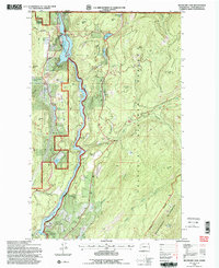
1992 Map of Boundary Dam
USGS Topo · Published 1997About this map
The Pend Oreille River carves a deep path through the northern reaches of the Colville National Forest in this early 1990s record of the Washington-Canada borderlands. Anchoring the northern end of the map is the massive Boundary Dam, where industrial infrastructure like substations and a gaging station contrast with the primitive terrain of Z Canyon. This era shows a landscape defined by heavy mining activity, particularly near the southern reach of the river where the Pend Oreille Mine, Grandview Mine, and Josephine Mine are situated near the community of Metaline.
Find a feature on this map
53 named features on this map. Tap any name to fly to it.
Don’t see what you’re looking for? This feature index may not catch every label — zoom into the map to look around manually.
Map Details
Editions of this 1992 Boundary Dam Map
2 editions found
Other maps of this area

1934 · Metaline
USGS Topo · 1:125,000

1942 · Metaline
USGS Topo · 1:125,000

1958 · Sandpoint
USGS Topo · 1:250,000

1963 · Sandpoint
USGS Topo · 1:250,000

1967 · Gypsy Peak
USGS Topo · 1:24,000

1967 · Boundary Dam
USGS Topo · 1:24,000

1967 · Metaline
USGS Topo · 1:24,000

1967 · Metaline Falls
USGS Topo · 1:24,000

1967 · Pass Creek
USGS Topo · 1:24,000
1967 · Abercrombie Mtn
USGS Topo · 1:24,000