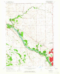
1963 Map of Bourbonnais
USGS Topo · Published 1965About this map
The Kankakee River bisects this landscape, shaping the growth of Bourbonnais, Bradley, and the northern edge of Kankakee. The river valley is preserved largely through Kankakee River State Park, which encompasses riparian features like Langham Island and Rock Creek. Rural life persists in the outlying townships of Rockville and Manteno, where small clusters like Deselm and Altorf are marked by their respective schoolhouses and the Deselm Cem.
Find a feature on this map
40 named features on this map. Tap any name to fly to it.
Don’t see what you’re looking for? This feature index may not catch every label — zoom into the map to look around manually.
Map Details
Editions of this 1963 Bourbonnais Map
3 editions found
Other maps of this area

1892 · Wilmington
USGS Topo · 1:62,500

1918 · Wilmington
USGS Topo · 1:62,500

1922 · Kankakee
USGS Topo · 1:62,500

1923 · Herscher
USGS Topo · 1:62,500

1924 · Kankakee
USGS Topo · 1:62,500

1925 · Herscher
USGS Topo · 1:62,500

1949 · Peotone
USGS Topo · 1:62,500

1953 · Peotone
USGS Topo · 1:24,000

1953 · Wilton Center
USGS Topo · 1:24,000

1953 · Symerton
USGS Topo · 1:24,000