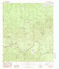
1984 Map of Boykin Spring
USGS Topo · Published 1984About this map
Angelina National Forest dominates this East Texas landscape, where the confluence of the Neches River and numerous tributaries creates a dense network of riparian environments. In the early 1980s, this area at the intersection of Angelina, Jasper, and Tyler counties preserved a distinct recreational and natural character. Landmarks like Boykin Spring Lake and Bouton Lake are nestled within the timberlands, while the northeastern corner of the map shows the influence of the Sam Rayburn Reservoir. The terrain is marked by subtle rises such as Cyclone Hill and unique local features like the Blue Hole and Rocky Springs. Small-scale drainage systems, including Big Creek and Millstead Branch, feed into the river valley, illustrating the complex hydrology that historically shaped the region's timber and recreational development.
Find a feature on this map
34 named features on this map. Tap any name to fly to it.
Don’t see what you’re looking for? This feature index may not catch every label — zoom into the map to look around manually.
Map Details
Editions of this 1984 Boykin Spring Map
2 editions found
Other maps of this area

1928 · Zavalla 3-c
USGS Topo · 1:24,000

1931 · Zavalla
USGS Topo · 1:62,500

1953 · Palestine
USGS Topo · 1:250,000

1954 · Beaumont
USGS Topo · 1:250,000

1955 · Woodville
USGS Topo · 1:62,500

1955 · Curtis
USGS Topo · 1:62,500

1957 · Beaumont
USGS Topo · 1:250,000

1957 · Palestine
USGS Topo · 1:250,000

1958 · Zavalla
USGS Topo · 1:62,500

1958 · Mc Gee Bend
USGS Topo · 1:62,500