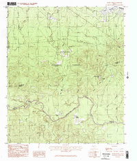
1984 Map of Boykin Spring
USGS Topo · Published 1984About this map
The Angelina National Forest dominates this East Texas landscape, where the confluence of the Neches River and numerous tributaries define the local geography. Surveyed in the late 1970s and early 1980s, the map captures a transition point in the Piney Woods where the northern reach of the Sam Rayburn Reservoir begins to back into the creeks. This area is defined by its recreation and water resources, notably featuring Boykin Spring Lake and the nearby Boykin Spring. Further south along the river drainage, Bouton Lake and the distinctive Blue Hole serve as key landmarks for those studying the hydrologic history of the Angelina and Jasper County lines. The terrain is characterized by subtle rises like Cyclone Hill and a dense network of named drainages, including Millstead Branch and Big Creek, reflecting the intricate watershed management of the mid-century forest service era.
Find a feature on this map
32 named features on this map. Tap any name to fly to it.
Don’t see what you’re looking for? This feature index may not catch every label — zoom into the map to look around manually.
Map Details
Editions of this 1984 Boykin Spring Map
2 editions found
Other maps of this area

1928 · Zavalla 3-c
USGS Topo · 1:24,000

1931 · Zavalla
USGS Topo · 1:62,500

1953 · Palestine
USGS Topo · 1:250,000

1954 · Beaumont
USGS Topo · 1:250,000

1955 · Woodville
USGS Topo · 1:62,500

1955 · Curtis
USGS Topo · 1:62,500

1957 · Beaumont
USGS Topo · 1:250,000

1957 · Palestine
USGS Topo · 1:250,000

1958 · Zavalla
USGS Topo · 1:62,500

1958 · Mc Gee Bend
USGS Topo · 1:62,500