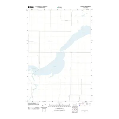
2011 Map of Braddock NW
USGS Topo · Published 2011About this map
Long Lake dominates this section of Burleigh County, its sprawling shoreline stretching diagonally across the prairie landscape. The water body is the central geographic feature, fed and drained by the winding course of Long Lake Creek as it meanders through the southern half of the quadrangle. This 2011 survey illustrates a highly structured rural environment defined by the Public Land Survey System, with a rigid grid of section-line roads like 102nd Ave SE and 353rd St SE providing access to the surrounding agricultural fields. The map captures the quiet, open character of the North Dakota plains, where the natural contours of the lake basin provide the only break in the geometric regularity of the county's road network.
Find a feature on this map
16 named features on this map. Tap any name to fly to it.
Don’t see what you’re looking for? This feature index may not catch every label — zoom into the map to look around manually.
Map Details
Editions of this 2011 Braddock NW Map
This is the sole edition of this map. No revisions or reprints were ever made.
Other maps of this area

1951 · McKenzie
USGS Topo · 1:62,500

1951 · Driscoll
USGS Topo · 1:62,500

1954 · Bismarck
USGS Topo · 1:250,000

1958 · Bismarck
USGS Topo · 1:250,000

1971 · Moffit SE
USGS Topo · 1:24,000

1971 · Moffit
USGS Topo · 1:24,000

1975 · Sterling
USGS Topo · 1:24,000

1975 · Lake Geneva
USGS Topo · 1:24,000
1975 · Driscoll
USGS Topo · 1:24,000

1975 · Dana
USGS Topo · 1:24,000