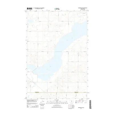
2014 Map of Braddock NW
USGS Topo · Published 2014About this map
Long Lake dominates this prairie landscape, stretching across a series of glacial depressions near the southern border of Burleigh County. The map reveals a highly structured grid of section-line roads, such as 48th Ave SE and 340th St SE, which define the agricultural character of this North Dakota region. The seasonal nature of the local hydrology is evident in the winding path of Long Lake Creek, which drains into the larger basin from the southwest. This 2014 survey captures a moment of modern land management where the geometric precision of the road network contrasts with the irregular, shifting shoreline of the lake. Located near the Burleigh and Emmons county line, the area remains primarily rural, with the topography showing subtle elevation changes characteristic of the surrounding plains.
Find a feature on this map
22 named features on this map. Tap any name to fly to it.
Don’t see what you’re looking for? This feature index may not catch every label — zoom into the map to look around manually.
Map Details
Editions of this 2014 Braddock NW Map
This is the sole edition of this map. No revisions or reprints were ever made.
Other maps of this area

1951 · McKenzie
USGS Topo · 1:62,500

1951 · Driscoll
USGS Topo · 1:62,500

1954 · Bismarck
USGS Topo · 1:250,000

1958 · Bismarck
USGS Topo · 1:250,000

1971 · Moffit SE
USGS Topo · 1:24,000

1971 · Moffit
USGS Topo · 1:24,000

1975 · Sterling
USGS Topo · 1:24,000

1975 · Lake Geneva
USGS Topo · 1:24,000
1975 · Driscoll
USGS Topo · 1:24,000

1975 · Dana
USGS Topo · 1:24,000