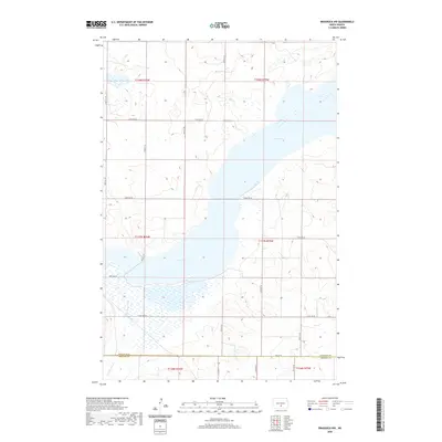
2020 Map of Braddock NW
USGS Topo · Published 2020About this map
Long Lake dominates this section of the North Dakota prairie, stretching across the landscape and defining the local drainage patterns. The map documents the transition from the glaciated plains of Burleigh County into Emmons County at the southern edge of the sheet. Water movement is central to the area's geography, with the lake feeding into Long Lake Creek, also labeled in portions as Long Lake Cr. The terrain is characterized by numerous small wetlands and depressions typical of the Missouri Plateau's pothole region. A strictly organized grid of section lines and rural roads, including 340th St SE and 141st Ave SE, provides the primary structure for land navigation and agricultural organization in this sparsely populated region.
Find a feature on this map
25 named features on this map. Tap any name to fly to it.
Don’t see what you’re looking for? This feature index may not catch every label — zoom into the map to look around manually.
Map Details
Editions of this 2020 Braddock NW Map
This is the sole edition of this map. No revisions or reprints were ever made.
Other maps of this area

1951 · McKenzie
USGS Topo · 1:62,500

1951 · Driscoll
USGS Topo · 1:62,500

1954 · Bismarck
USGS Topo · 1:250,000

1958 · Bismarck
USGS Topo · 1:250,000

1971 · Moffit SE
USGS Topo · 1:24,000

1971 · Moffit
USGS Topo · 1:24,000

1975 · Sterling
USGS Topo · 1:24,000

1975 · Lake Geneva
USGS Topo · 1:24,000
1975 · Driscoll
USGS Topo · 1:24,000

1975 · Dana
USGS Topo · 1:24,000