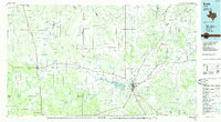
1985 Map of Brady
USGS Topo · Published 1985About this map
The Brady Mountains form a significant physical divide across the center of this West Texas landscape, marking the transition between the rolling plains and the river basins of the southern edge of the Edwards Plateau. Centered on the city of Brady, the map illustrates a region defined by its intersection of major transportation routes including U S 87 and the Gulf Colorado and Santa Fe Railway. The northern boundary is traced by the winding Colorado River, while the San Saba River cuts through the southeastern corner, anchoring a series of small agricultural communities like Voca and Rochelle. Local genealogists will find value in the detailed locations of small settlements such as West Sweden and East Sweden, as well as the proximity of Rest Haven Cem and Catholic Cem to the regional hub at Brady, reflecting the mid-1980s settlement patterns of McCulloch and Concho counties.
Find a feature on this map
65 named features on this map. Tap any name to fly to it.
Don’t see what you’re looking for? This feature index may not catch every label — zoom into the map to look around manually.
Map Details
Editions of this 1985 Brady Map
2 editions found
Other maps of this area

1885 · San Saba
USGS Topo · 1:125,000

1887 · Llano
USGS Topo · 1:125,000

1887 · Mason
USGS Topo · 1:125,000

1887 · Coleman
USGS Topo · 1:125,000

1889 · Brownwood
USGS Topo · 1:125,000

1889 · Coleman
USGS Topo · 1:125,000

1891 · Hayrick
USGS Topo · 1:125,000

1892 · San Angelo
USGS Topo · 1:125,000

1892 · Eden
USGS Topo · 1:125,000

1892 · Ballinger
USGS Topo · 1:125,000