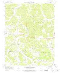
1960 Map of Branch
USGS Topo · Published 1975About this map
The Little Niangua River carves a winding path through the borderlands of Camden, Hickory, and Dallas counties, serving as the dominant geographic feature in this 1960s-era landscape. The region is defined by its rural community centers and small-scale watercourses, including Cahoochie Creek and Darby Branch. Social life and local history are anchored by several country houses of worship, such as Little Niangua Ch and Hickory Grove Ch, which mark the intersections of the era's developing road network. Notable for its elevation, the Branch Lookout Tower overlooks the surrounding townships of Stark and Russell. Genealogists may find value in the location of the Stanton Cem, while the small settlement of Zeewick stands as a focal point for researchers tracking the mid-century population patterns of this Missouri Ozarks periphery.
Find a feature on this map
30 named features on this map. Tap any name to fly to it.
Don’t see what you’re looking for? This feature index may not catch every label — zoom into the map to look around manually.
Map Details
Editions of this 1960 Branch Map
2 editions found
Other maps of this area

1884 · Bolivar
USGS Topo · 1:125,000

1887 · Warsaw
USGS Topo · 1:125,000

1888 · Versailles
USGS Topo · 1:125,000

1892 · Bolivar
USGS Topo · 1:125,000

1893 · Versailles
USGS Topo · 1:125,000

1894 · Warsaw
USGS Topo · 1:125,000

1934 · Macks Creek
USGS Topo · 1:48,000

1935 · Barnumton
USGS Topo · 1:24,000

1939 · Macks Creek
USGS Topo · 1:62,500

1947 · Jefferson City
USGS Topo · 1:250,000