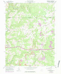
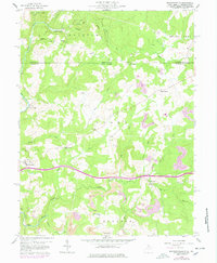
1959 Map of Brandonville
USGS Topo · Published 1984About this map
The Pennsylvania West Virginia border divides this 1959 survey, where the northern reaches of Preston County meet Fayette County. This high-plateau landscape is defined by the drainage basins of Sandy Creek and Little Sandy Creek, which once powered the industry at Clifton Mills. The settlement pattern centers on small rural hubs such as Brandonville and Hazelton, connected by a network of winding roads and local landmarks like Salem Sch and several country churches, including Shady Grove Ch and Locust Grove Ch.
Find a feature on this map
44 named features on this map. Tap any name to fly to it.
Don’t see what you’re looking for? This feature index may not catch every label — zoom into the map to look around manually.
Map Details
Editions of this 1959 Brandonville Map
6 editions found
Other maps of this area

1900 · Accident
USGS Topo · 1:62,500

1900 · Uniontown
USGS Topo · 1:62,500

1904 · Bruceton
USGS Topo · 1:62,500

1922 · Confluence
USGS Topo · 1:62,500

1926 · Bruceton
USGS Topo · 1:62,500

1931 · Uniontown
USGS Topo · 1:62,500

1931 · Confluence
USGS Topo · 1:62,500

1931 · Bruceton Mills
USGS Topo · 1:62,500

1933 · Confluence
USGS Topo · 1:62,500

1933 · Bruceton
USGS Topo · 1:62,500